 Subscribe to Newsletter
 Donate
 Shop
Shop 0
0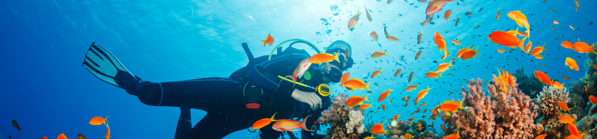
| The Transect Line – April/May 2010 | |
| NEWS ALERT! Florida Braces for Oil Spill | |
| The continuing huge oil spill in the Gulf of Mexico could reach the Florida Keys in the next few days if wind and currents push them in that direction. Reef Check has reached out to potential volunteers from a number of groups and created a plan to try to to assist state and federal authorities to protect what can be protected and to document impacts of the oil. Interestingly, there is conflicting information about direct impacts of various types of oil on coral reef organisms, but most experts seem to agree that seagrass beds and mangrove forests are highly vulnerable. Because adult corals themselves have a mucous coating, this helps to protect them from some effects. But since each type of oil is quite different, no one really knows what the effects of this spill will be on the thousands of species of organisms found on Florida reefs. Damage from the Exxon Valdez spill is still continuing 20 years later. If you are interested to help join the efforts to protect Florida’s reefs, please contact William Djubin at 561-308-8848 or info@oceanrehab.org. | |
| Preliminary Surveys of Haiti Coral Reefs Show No Damage From Earthquake | |
| By Reef Check Executive Director Dr. Gregor Hodgson
The two locations surveyed were: As expected, no damage was found at the Arcadine Islands. Several years ago, Jean Weiner, the Haitian marine biologist heading up FoProBim, wisely recommended to the President of Haiti that this area become the first Marine Protected Area in the country. The reefs here are far from sedimentation that affects many coastal areas of Haiti due to runoff from eroded land. The Arcadine reefs are structurally complex with between 50 to 80% living coral. Coral diversity is high with both staghorn and elkhorn coral present. Reef Check high value human impact indicators such as grouper and lobster are rare. There are few fish and most are less than 20 cm in length. I surveyed the reefs off Jacmel in 1984, so it was important to return there to compare the condition of those reefs. Driving over the mountains to Jacmel in post-earthquake Haiti is quite an expedition. The roads are a mess on the outskirts of the capital and pass through some of the most heavily damaged areas near the epicenter. Tent cities line the road throughout the entire journey, and collapsed buildings – some simply piles of rubble — are everywhere.
Following the 2004 earthquake in Aceh, Indonesia, Reef Check surveyed the reefs of Aceh and found significant structural damage in some areas. While the survey of reefs in Jacmel was much smaller, surprisingly, there was no evidence of direct earthquake damage to reefs just a few yards offshore of heavily damaged hotels. Even very delicate structures such as 10 m long underwater arches and large coral heads balanced on thin pedestals were undamaged. In fact, the several kilometers of reef surveyed off Jacmel are in better condition than many of those in Florida, and included large stands of the Elkhorn coral Acropora palmata, now on the US Endangered Species List. The long-spined black sea urchin Diadema – a Reef Check indicator — is abundant, and schools of 50 to 70 small snapper and blue tangs are common. The surgeon fish and urchins have grazed the algae down to bare rock! No silt was present. Based on the colony sizes, the reefs of Jacmel are clearly in recovery mode following the 1980s die off of urchins, and the 2005 Caribbean bleaching event. |
|
| Reef Check California Update | |
April is the start of the field season for Reef Check California (RCCA). This month we had several of our annual recertifications for Reef Check divers as well as trainings for new divers. We recertified Reef Checkers in Monterey and Los Angeles and trained a group of new divers over two weekends in Los Angeles. I would like to welcome these new divers to the team! For me, the LA recertification at Catalina was my first day of being in the field and diving with Reef Check. I met many of the dedicated volunteers and watched how they surveyed rocky reefs. I enjoyed the great work and attitude of the Reef Check volunteers. Not only did everyone get recertified on this trip, but we also saw a variety of wildlife including a black sea bass during one of the dives and whales on the way back from Catalina to Long Beach harbor. Altogether we recertified and trained a total of 76 divers in April that are now ready for the 2010 survey season. Some of them have already started to survey in Southern California – kicking off our 2010 survey season. In northern California we continue to work with our collaborators on the baseline monitoring of the MPAs between Bodega Bay and Point Arena for the MLPA initiative. Over the last months we have further developed collaborations with academic and other citizen science groups to integrate monitoring efforts in this region. Further, RCCA joined the Central and Northern California Ocean Observing System (CeNCOOS), an organization that fosters coordination of marine observation to inform decision makers and the public. Working with this group will make RCCA’s data available to other groups working in the same region and increase the programs visibility through CeNCOOS’s data portals. As we move into the 2010 survey season there are still possibilities to become a new Reef Check diver and get involved in this year’s data collection. Please check the training schedule on our website, or if you are already part of the Reef Check team you can sign up for recertification. The survey dates and locations are listed on the RCCA forum so if you want to get out and participate, check there for updates and to sign up. |
|
| Technical Question of the Month | |
 Each month, Reef Check will answer a technical question regarding the monitoring protocol of our coral reef or rocky reef programs. If you have a question you would like answered, please email rcinfo@reefcheck.org. Each month, Reef Check will answer a technical question regarding the monitoring protocol of our coral reef or rocky reef programs. If you have a question you would like answered, please email rcinfo@reefcheck.org.
Reef Check California — How do we count fish along a transect without double counting fish that move around? To count fish in the rocky reef habitat in California, we use visual surveys of 30m transects. To count fish along the transect, a buddy pair of divers swim along the reef, laying out the meter tape while at the same time the lead diver counts all individuals of the 35 fish species targeted by RCCA within a 2 x 2 meter box. Additionally they record the size of each individual in one of five size categories ranging from less than 15 to more than 50 centimeters. This or similar survey methods are used by many subtidal researchers working on temperate rocky reefs. Since fish move around and can swim in and out of the 2 x 2 meter box along the transect we use an approach that we call: stop, scan and search. To implement this method along the transect the fish-counting diver moves in stages. At the beginning of each stage the diver stops and scans the water ahead for mobile fish within an elongated imaginary box of 2 x 2 meters. During the scan all conspicuous individuals within the imaginary box in front of the diver are quickly counted. How far ahead the diver scans for fish depends on the visibility during the dive. Fish that move into the area after the scan are not considered and fish that leave the area after the scan are still recorded even if they are not present by the time the diver gets to writing down the data. This scan creates a snapshot of a section of the transect and only fish present during this snapshot are counted. After the scan the diver searches for fish that are hidden in cracks and crevices as he or she moves on through the section of the transect that was scanned. At the end of the scanned area the diver stops and scans the section ahead of him or her creating the next snapshot of data, than moves on and searches for cryptic fish. These steps are repeated until the end of the transect is reached. This method insures that each fish is only counted once. Subdividing the transect into sections makes it more manageable for the diver to count moving fish. |
|
| In Memory of Allan Smith | |
 Reef Check has lost a valued colleague- Allan Smith died in London on Wednesday March 24th after a long and difficult battle with cancer. He is perhaps best known as the Caribbean’s foremost expert on marine algae, but was also well known for his involvement in many conservation activities, monitoring and sustainable use of natural resources throughout his career. Allan was a long-term supporter of Reef Check; since 1999, he was a Team Scientist and Coordinator for Reef Check St Lucia, organizing and participating in many surveys, and heading an International Reef Check Workshop in 2001. Apart from being able to identify just about anything green that you could find in the sea, he put his knowledge of marine algae to practical use. He developed techniques for seamoss farming in St Lucia and was instrumental in getting many farms started throughout the eastern Caribbean. He was also an excellent underwater photographer and his images have been widely used in educational materials including a 1980s issue of postage stamps in Barbados. Later in his career, he took up resource mapping and pioneered the use of kites and other technology for getting aerial photographs of reefs and mangroves. Reef Check has lost a valued colleague- Allan Smith died in London on Wednesday March 24th after a long and difficult battle with cancer. He is perhaps best known as the Caribbean’s foremost expert on marine algae, but was also well known for his involvement in many conservation activities, monitoring and sustainable use of natural resources throughout his career. Allan was a long-term supporter of Reef Check; since 1999, he was a Team Scientist and Coordinator for Reef Check St Lucia, organizing and participating in many surveys, and heading an International Reef Check Workshop in 2001. Apart from being able to identify just about anything green that you could find in the sea, he put his knowledge of marine algae to practical use. He developed techniques for seamoss farming in St Lucia and was instrumental in getting many farms started throughout the eastern Caribbean. He was also an excellent underwater photographer and his images have been widely used in educational materials including a 1980s issue of postage stamps in Barbados. Later in his career, he took up resource mapping and pioneered the use of kites and other technology for getting aerial photographs of reefs and mangroves.
Originally from Zimbabwe, where his mother still lives, Allan obtained his BSc in Botany from the University of Aberdeen in 1971. He was awarded an MSc from the Institute of Oceanography, McGill University in 1979, for his thesis entitled ‘Mariculture and polysaccharide chemistry of the red alga Gracilaria tikvahiae.’ For nearly 20 years (1985-2004) he was a research scientist with the Caribbean Natural Resources Institute (CANARI), based in St Lucia. After CANARI moved to Trinidad he stayed in St. Lucia as a Research Associate with CANARI and started his own consulting business Resource Management Technologies Ltd., focusing on the assessment and mapping of coral reef and mangrove systems, and provision of training in participatory mapping and PGIS. Allan was always happiest in the field whether researching, mapping, working with community groups or teaching (or all four at once). Yet he was equally at home in front of the computer screen generating maps from Mapmaker and writing manuals. He was a humble man, but contributed immeasurably to the development of an environmental consciousness, especially among local fishers and community groups. His technical skill, extensive knowledge of the Caribbean marine environment and patience with those who wanted to learn will be missed by many. |
|
| British Virgin Islands Coral Reef Week | |
 By Reef Check Executive Director Dr. Gregor Hodgson By Reef Check Executive Director Dr. Gregor Hodgson
The Reef Check team in the British Virgin Islands (BVI) has been faithfully monitoring four reef sites per year since the inception of Reef Check in 1997. This year, Trish Baily, the energetic leader of RC BVI, invited RC International Director Dr. Gregor Hodgson to Tortola to hold meetings, give seminars, and facilitate a workshop on “Enhancing Monitoring and Management of Coral Reefs in BVI” during April 13 to 17. Trish, who captains the lovely charter yacht Serendipity and specializes in EcosailingTM adventures — had participated with Greg in one of the first RC Training workshops in Lembongan, Bali in 2000. The goal of the BVI Workshop was to review the current status of coral reef monitoring in the BVI with interested stakeholders (government departments, private businesses, academics and other non-governmental organizations) and to identify gaps and try to fill them. The week began with an aerial fly-over of the islands courtesy of Island Birds Air Charter. This revealed the dispersed geographic layout of the islands and their close proximity to the US Virgin Islands. Each of the 50-odd islands is circled by fringing reef. The longest reef runs along the north coast of uninhabited Anegada Island and then continues for about 1 km extending like a tail. From the air, the beaches and azure waters were gorgeous, but the highlight of th Following the fly-over, Trish and several RC BVI ‘regulars’ enjoyed a scuba dive and snorkel at nearby reefs courtesy of Johann and Belinda of Dive BVI, a top local dive company. The good news is that the coral diversity is still very high at a number of sites and the Elkhorn coral Acropora palmata is making a comeback in at least one location assisted by the long-spined black sea urchin Diadema. In the 1970s, Elkhorn coral was the primary framework builder of the inner reef flats in the Caribbean. Now on the US Endangered Species List, Elkhorn is rare throughout the Caribbean, therefore seeing a few patches of healthy Elkhorn is a significant indication of recovery. During an evening event hosted by his Excellency the Governor, David Pearey, he noted how much he had enjoyed a recent scuba dive and pointed out the need to educate more BVI children about the ocean. One of the issues on most Caribbean Islands is that few children learn how to swim, let alone snorkel. This is a cultural issue based on stories of the dangers of the sea passed on from generation to generation. So one of the goals of the week was to identify organizations involved in youth education which might be potential partners wit |
|
| Managing Reef Fisheries in Mexico | |
 By Reef Check’s Executive Director Dr. Gregor Hodgson and Program Manager, Outreach & Mexico Mary Luna By Reef Check’s Executive Director Dr. Gregor Hodgson and Program Manager, Outreach & Mexico Mary Luna
Currently, most Mexican fisheries for species like grouper and snapper are managed by permits only, with no fishing quotas, so there is no limit on catch. Mexico has been lucky. Some 75% of the world’s fisheries have either collapsed or are overfished, however, there are still fish to catch in Mexico – particularly on both sides of Baja California. But for how long? Following the success of Reef Check partnering with the Mexican NGO Comunidad y Biodiversidad (COBI) to create a sustainable marine aquarium fishery in the Gulf of California, the question was raised if we could apply the same strategy to reef fish caught for food on either side of the Baja peninsula. Interestingly, this same question currently faces fishery managers in the state of California in the US. More on that later. Reef Check and COBI held a fisheries management Workshop on April 8 and 9 to examine this question. The Workshop participants reviewed monitoring methods, stock assessment models and new analytical approaches that could be used to help manage coral reef and rocky reef fin fish species of the Baja Peninsula. The workshop was led by Dr. Andrea Saenz Arroyo of COBI and Dr. Gregor Hodgson, RC’s Executive Director, and was hosted by the School for Fields Studies (SFS) in Puerto San Carlos, on the Pacific coast of Baja California Sur, Mexico at the edge of the famous Magdalena Bay. Participants came from several non-profits and government agencies. Francisco Fernandez, a COBI marine biologist, presented the case study of the small aquarium fish cooperative “Mujeres del Golfo,” in Loreto, and explained how the women have successfully applied MAQTRAC to sustainably manage their aquarium fishery. The MAQTRAC methodology was developed by Hodgson and ichthyologist Dr. Domingo Ochavillo as part of a larger project for managing the aquarium trade in far away South East Asia. It consists of two manuals, one for field data collection, and the other for data analysis and calculation of fishing quotas. The basic issues of monitoring, analyzing and managing fisheries are the same everywhere. The major difficulties involved in trying to monitor reef fish species are that data are difficult and expensive to obtain either direct by observation by divers or through experimental fishing or surveys of fish |
|
| 1st Annual Punta Sayulita Classic Benefits Reefs | |
 The 1st Annual Punta Sayulita Longboard & Stand-Up Paddle Classic was held on April 17-18 in Sayulita, a quaint beach town located 30 min north of Puerto Vallarta on the west coast of mainland Mexico. Proceeds raised from the Classic benefitted the Punta Sayulita Foundation and the local Chapter of Reef Check (RC). Mary Luna, RC’s Mexico Program Manager and an avid surfer, was on hand to help with the festivities and thank the organizers, Punta Sayulita Development for their support. The 1st Annual Punta Sayulita Longboard & Stand-Up Paddle Classic was held on April 17-18 in Sayulita, a quaint beach town located 30 min north of Puerto Vallarta on the west coast of mainland Mexico. Proceeds raised from the Classic benefitted the Punta Sayulita Foundation and the local Chapter of Reef Check (RC). Mary Luna, RC’s Mexico Program Manager and an avid surfer, was on hand to help with the festivities and thank the organizers, Punta Sayulita Development for their support.
Building on this effort, RC will work with the Punta Sayulita development to launch Sayulita’s Adopt-A-Reef Program this summer. As part of this program RC will train a team of local divers in the RC EcoDiver monitoring methodology. Plans are also underway to build a coral garden inside the bay, and to transplant some coral fragments to an area near Punta de Mita that was devastated by a hurricane a few years back. Annual surveys by the local RC team will provide feedback on the conditions of Sayulita reefs and others nearby. This data will help managers make more informed decisions over the management of their reefs. Event organizer Kevin Roberts of Punta Sayulita said “We are very excited to launch The Classic contest with the overwhelming support and assistance we have received from our professional surfers, sponsors, volunteers and the Sayulita community. Sayulita is the ideal location to hold an international surfing event like the Classic and we are pleased it has attracted some of the top professional longboard and SUP surfers to the field seeing that this is the event’s first year. We look forward to growing the event each year and raising as much money as possible for Reef Check and Punta Sayulita Foundations. We feel the mix of a surf contest showcasing some of the best professional and amateur surfers with a variety of Stand-Up Paddle distance races will give spectators plenty of action to watch and also enjoy time with their friends and family in Sayulita.” |
|
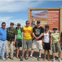
| 2010 Dive EcoExpedition to Isla Natividad | |
 Embark on a fantastic and unique kelp forest adventure! Embark on a fantastic and unique kelp forest adventure!
Dates: July 9 – 15, 2010 Dive in one of the best preserved kelp forest ecosystems in the California Current, witness the progressive management techniques of the Natividad community, and contribute to preserving Baja’s biological richness. Join this EcoExpedition as a certified Reef Check California diver or a non-certified guest, and fly directly from San Diego into Natividad, where superb diving and a fantastic cross-cultural experience await you! This rugged region offers you encounters with many exciting species such as rays, lobster, abalone, sheephead, bottom dwelling sharks, sea bass, whitefish, yellowtail, and the endangered black-vented shearwater. This is Northern Baja like you’ve never seen it before! For more information, please contact Reef Check’s Mexico Program Manager Mary Luna or click here. |
|

 In Jacmel, many coastal hotels were flattened or badly damaged. Surprisingly, the water was clear and the reefs were in similar condition to those in the Arcadines, with up to 80% living coral, a high level of diversity and excellent reef structure to serve as fish habitat.
 e flight was a mother and calf humpback whale.